VISITING THE CUBE

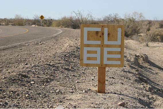
VIEW MAPSMexicali is the recommended port of entry into Mexico to get to the Cube, regardless of your starting point. You can click on the “view maps” button [above left] to get a detailed route map from Mexicali to the Cube which can easily be printed. As with many journeys, it's the last mile which is the most critical. Assuming that you have successfully navigated your way to San Felipe and found the road out of the town towards Puertecitos (Highway 5), here is what to look out for: along the way there are markers giving the distance from San Felipe in kilometers. The turnoff for the Cube is just past km 41 where the road makes an S bend. Begin to slow down at the 41 km marker. You will see a small sign on the right with the Cube logo. It has reflective tape so it will show up at night. At the sign, make a left turn and you will greeted by a large sign with a green lounging lizard. This marks the beginning of the approach road to the Cube. Follow the dirt road due West about 500 yards and turn right at the end. You should now get your first view of the Cube. (See note about parking below). Follow the road down the hill and bear left. Traverse the wash quickly using the driving technique shown below, drive up the ramp and park either to the left or the right of the building.
REFRESH PAGE TO REPLAY
[above] Watch for the Cube sign by the roadside at Km 41.5. When you see the sign make an immediate left turn onto a dirt road (see detail map)
[above] Traversing the wash
CUBE PARKING
1. Stop before you traverse the wash
2. Walk up to the Cube and inspect the parking area
3. Make sure there is not too much sand there to park safely
Fueling up It's a good idea before you leave North America to top off your gas tank. There are several handy stations in the border town of Calexico. Many people claim that Mexican gas is inferior, so you take your chances. But it is sometimes cheaper South of the border, and you get your windows washed and full old fashioned service at most stations. If you do wait to fuel up at a Pemex be sure to do so before entering the 150 mile stretch to San Felipe during which there is no gas station. The last Pemex is at a pueblo called La Puerto about 20 miles South of the Mexicali border.
Crossing the border The Mexicali border is easy to cross and delays are rare. Use the “Nothing to Declare” lanes unless you are importing something valuable. Drive slowly and wait for the green light and the barricade to lift. Always stop if flagged down by an officer. They may search your vehicle. They are looking for guns. Don't bring any.
Navigating Mexicali After going through the border checkpoint bear right onto a major roadway with a big island down the center.
From that point, stay in the middle lane all the way out of Mexicali to avoid buses and people turning left. There are a few newly built freeway-like overpasses that have somewhat unpredictable exits and side roads that you will not want to take by accident. If you stay in the middle lane and follow the major traffic flow you will make it out of Mexicali quite quickly.
There are three major driving circles you will go through. Stay in the middle lane and follow along with the through traffic on the first two. When you enter an industrial area and see The Home Depot on the left you are approaching the third circle where you will bear right across the train tracks. Follow signs for Highway 5 San Felipe. Soon after the turn you will pass a Mega shopping center on the left. This road goes all the way to San Felipe and beyond to the Cube.
Checkpoint The highway South of Mexicali has recently been repaired and the road surface of the mostly 2 lane highway is good. There are long stretches of desert and some low mountain ranges to traverse. Traffic is generally light. About 20 miles north of San Felipe is an army checkpoint where the road from Ensenada joins Highway 5. You must stop and let them inspect the vehicle unless they wave you on. Don't be alarmed by their weapons and be patient. They are always polite and they don't expect you to understand Spanish.
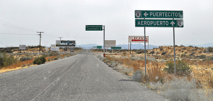
Navigating San Felipe Once you have arrived in San Felipe and have passed a driving circle with big double white arches at the entrance to town you will soon come to another driving circle with trees and grass on it. Watch out for the many stop signs between the two circles, some of them lurking behind palm trees! You will notice than many of the side streets are unpaved. You will notice a large Calimax market on the right where provisions may be obtained, bearing in mind that grocery stores are few and far between in the area. As you enter the second driving circle and proceed along the driving rotation, turn on the first right street and exit the driving circle. Another market—BJ's will be to the right. This road will take you through the South end of San Felipe and past the harbor. The road surface for this stretch is poor and there are potholes and occasional speed bumps to negotiate. After about 5 miles look for a T intersection with a sign for Aeropuerto (straight) and Puertecitos Highway 5 (left). Here you will stop and make a full 90° left turn. From this point follow the directions above.
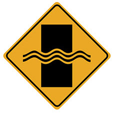
Watch out for the dips The road surface from San Felipe to the Cube is quite good but there there are dozens of dips or vados (fords) along the way every kilometer or so. They are supposed to let water flow across the road at controlled points during rare but devastating flash flooding. Most of them are amusing in a roller coaster sort of way, but a few are quite serious and will require your driving attention, especially at night. All dips are posted with signs—the more frightening ones have diagonal reflective tape on the sign, and often some kind of warning painted on the roadway. From round about km 27 onward are the more extreme dips to contend with.
TRAVEL TIPS
Updated April 2015
From San Diego to The Cube it is about 280 miles one way and 560 miles round trip. Depending on the border delay and any stops along the way it can take between 5 and 7 hours to get to San Felipe. It is about 150 miles from the Mexicali border to San Felipe.
There are no current road repairs and diversions en route.
Are we there yet?
It takes about 32 miles from the San Felipe main arches to about 28 additional miles from the south end of San Felipe to arrive at The Cube. That drive can take another 30 to 45 minutes.
Watch out for the stops
When traveling in Mexico a total stop at all stop signs is advised. Mexican traffic lights blink green before turning yellow and then red. Be cautious and stop at the blinking green if possible, and never run a red light.
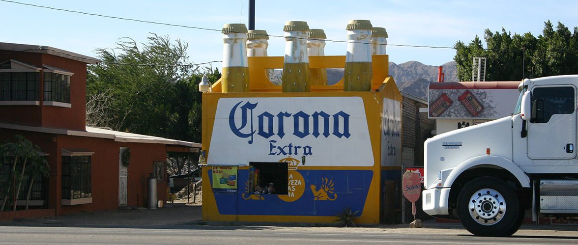
[below] Roadside attractions on the way to the Cube include the El Faro liquor store